Physiographic Map of North and Central Eurasia (Sample record, please remove!)
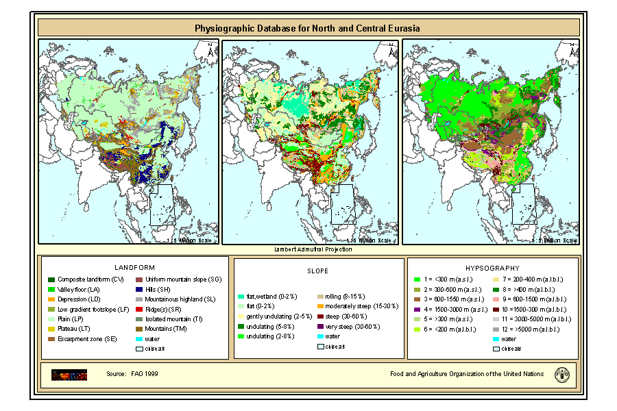
Physiographic maps for the CIS and Baltic States (CIS_BS), Mongolia, China and Taiwan Province of China. Between the three regions (China, Mongolia, and CIS_BS countries) DCW boundaries were introduced. There are no DCW boundaries between Russian Federation and the rest of the new countries of the CIS_BS. The original physiographic map of China includes the Chinese border between India and China, which extends beyond the Indian border line, and the South China Sea islands (no physiographic information is present for islands in the South China Sea). The use of these country boundaries does not imply the expression of any opinion whatsoever on the part of FAO concerning the legal or constitutional states of any country, territory, or sea area, or concerning delimitation of frontiers. The Maps visualize the items LANDF, HYPSO, SLOPE that correspond to Landform, Hypsometry and Slope.
Standaard
- Versiedatum (Publicatiedatum)
- 1999-10-01
- Versie dataset(serie)
-
First
- Wijze van presentatie
- mapDigital
- Status
- compleet
- Frequentie
- indien nodig
- theme
-
-
physiography, soil
-
- place
-
-
Eurasia
-
- (Juridische) toegangsbeperking
- copyright
- (Juridische) gebruiksbeperking
- copyright
- Ruimtelijk schema dataset(serie)
- vector
- Noemer
- 5000000
- Karakterset
- utf8
- Categorie(en)
-
- Geo wetenschappelijke data
- Begindatum
- 2000-01-01T04:29:00
- Einddatum
- 2008-01-08T04:29:00
))
- Aanvullende informatie
-
The maps are included in the SOIL and TERRAIN Database for Northern and Central EURASIA CD-ROM , which contains also the Soil map of North and Central Eurasia, reports and databases. Copies of this CD-Rom can be ordered from: Sales and Marketing Group FAO, Viale delle Terme di Caracalla, 00153 Rome, or by email to Publications-sales@fao.org. The terms and definitions used in the Physiographic database are based on the procedures manual for ?Global and National Soils and Terrain Digital Databases (SOTER)?, prepared by UNEP, ISSS, ISRIC and FAO and published by FAO as World Soil Resources Report #74 Rev1 (1995). Refinements were made in China as part of the preparation of a physiographic map for Asia, work carried out by G. van Lynden for FAO as part of the ASSOD project.
- Referentiesysteem identificator
- Lambert Azimuthal Projection
- Topologie level
- abstract
- Geometrisch objecttype
- complex
- Online bronnen
-
phy.zip
(
WWW:DOWNLOAD-1.0-http--download
)
Physiography of North and Central Eurasia Landform (Gif Format)
- Online bronnen
-
geonetwork:phy_landf_7386
(
OGC:WMS
)
Physiography of North and Central Eurasia Landform
- Online bronnen
-
geonetwork:phy_slope_7386
(
OGC:WMS
)
Physiography of North and Central Eurasia Slope
- Online bronnen
-
geonetwork:phy_hypso_7386
(
OGC:WMS
)
Physiography of North and Central Eurasia Hypsography
- Niveau kwaliteitsinformatie
- dataset
Meta-metadata
- Metadata identificator (fileIdentifier)
- 78f93047-74f8-4419-ac3d-fc62e4b0477b XML
- Karakterset
- utf8
- Metadata wijzigingsdatum
- 2007-11-06T12:10:47
- Naam metadatastandaard
-
ISO 19115:2003/19139
- Versie metadatastandaard
-
1.0
Overzichten
Ruimtelijke dekking
Verzorgd door
